
3.15 Land Composition
3.15 Land Composition
Project Name: MAvES (Mapping, Assessment and Valuation of Ecosystems and their Services) (JRC-D3- Institutional project)
| Pillar of Sustainable Development | Societal challenge |
|---|---|
| Planet | 3 - Green Space Management |
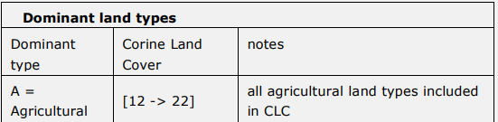
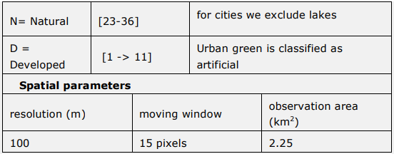
Description | Land composition or co-occurrence of land use types, is a measure of spatial distribution of elements or components of a landscape. To quantify land composition we use the Landscape Mosaic (LM), model available in Guido's tool box (Vogt and Riitters 2017). A land mosaic is a tri-polar classification scheme that represents the land type dominance, the interface zone and the mix zone within a defined area. The classification uses the threshold values of 10%, 60%, and 100% along each axis to partition the tri-polar space into 19 classes. These threshold values are indicative for the presence (10%), dominance (60%), or uniqueness (100%) of each land cover type. The model measures land type heterogeneity and allows to consider trade‐offs occurring between intra-land type changes (i.e., modification of the area of a given land type) and inter land types changes (i.e., direction of change). It provides a measure of the relative contributions of the three key land types in percentage within a given neighborhood/observation area. Land composition is used to assess the co-occurrence of land types within each Functional Urban Area. It represents the arrangements of ecosystem types within and around cities. |
Scale as linked to D2.2 framework |
|
Data source [ link to data framework] |
|
Data needs |
|
Expected Outputs |
|
Calculation methods |
|
Links and references |
|
Revisions
| Version | Name | Date | Changes made |
| 0.1 | Emily (EcoWise) | 17/01/2022 | Factsheet created |