
6.17 Areal sprawl
6.17 Areal sprawl
Project Name: Nature4Cities
| Pillar of Sustainable Development | Societal challenge |
|---|---|
| People | 6 - Place Regeneration |
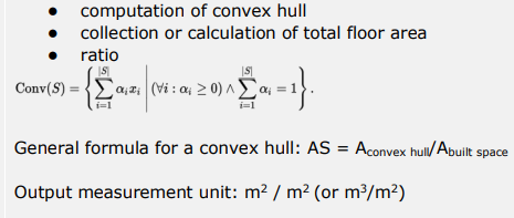
Description | Areal sprawl indicator describes the level of compactness of a city, as the ratio between total building floor area to the area of the convex hull of the built space. The convex hull of a set of points is the minimal convex envelope that contains those points. Computing this shape gives a fair ground to compare different cities or neighbourhoods, and a closer approximation to the actual built density. Areal sprawl is the territorial aspect of several urban transitions. According to literature (Speck, 2013; Saelens et al. 2003.) the planning of city centres can avoid areal sprawl. If downtown is liveable, less people will tend to move to the outskirts of the city and undertake the burden of daily commute for the desired quality of their place of residence. Nature-based solutions are highly relevant from compact urban form point of view. Compactness can be also achieved with the balanced availability of green spaces and ecosystem services. In addition, unrestricted urban sprawl endangers natural environment around the city and the protective zones that mitigates the intensity of urban heat island. |
Scale as linked to D2.2 framework |
|
Data source [ link to data framework] |
|
Data needs |
|
Expected Outputs | |
Calculation methods |
|
Links and references |
|
Revisions
| Version | Name | Date | Changes made |
| 0.1 | Emily (EcoWise) | 25/01/2022 | Factsheet created |
