
8.1.1 SI - Segregation Index
8.1.1 SI - Segregation Index
| Topic | Urban challenges | Sub-challenges |
|---|---|---|
| Social | 8 - Urban Planning and Governance | 8.1 - Governance in Planning |
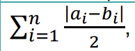
Description | One of most important social transitions is the process of segregation. Segregation shows the spatial separation of different social strata in a given spatial area. Various indices have been developed to measure segregation that differ in complexity and explanatory power. Here a rather simple but widely used one suffices. Duncan and Duncan index of dissimilarity delineates the segregation of a neighbourhood or a district, in per cent. It shows the ratio of the population having to move to have an equal distribution. It calculates the segregation of a select stratum that is to be selected according to the nature of the study, that is, in this case, the upper strata. As educational level is the best proxy to social status, we suggest it as the variable and the university degree as the value to be assessed. Segregation index is related to the development of NBS in the following ways:
It is easily seen that the accessibility of green spaces and social segregation within the city are strongly interconnected. The social impact of NBS projects can be traced by the spatial or temporal alterations of the segregation index. Correlation can be proved between segregation and the development of green infrastructure, if the implementation of a large scale and complex NBS project has measurable social effect. (Irvine et al. 2013, Haffner 2015, Dooling 2009, Checker 2011) |
Scale as linked to D2.2 framework | Delete as appropriate:
|
Data source [ link to data framework] |
|
Data needs |
|
Expected Outputs |
|
Calculation methods |
|
Links and references |
|
Revisions
| Version | Name | Date | Changes made |
| 0.1 | Emily (EcoWise) | 05/01/2022 | Indicator created |