
8.2.1 ACC - Accessibility
[Indicator ID] [INDICATOR NAME]
| Topic | Urban challenges | Sub-challenges |
|---|---|---|
| Social | 8 - Urban Planning and Governance | 8.2 - Urban Planning and Form |
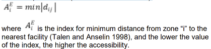
Description | Accessibility is an indicator describing the quality of a particular entity of being reached. In this case accessibility is measured referring to green spaces and their walking distance from residential areas. Concluding this indicator is measuring the walking distance between a certain point (residential building) and the nearest green space. However, Accessibility gives information on the residential a building itself, and thus the spatial distribution of green spaces in the city. Accessibility can be measured in several ways. We can distinguish different methodologies based on what types of NBS are taken into account: only green spaces above a certain area or we can also consider linear and spot-like NBSs too. On the other hand, we can also calculate accessibility based on the radius of certain NBSs or based on the walking distance between two points. |
Scale as linked to D2.2 framework |
|
Data source [ link to data framework] |
|
Data needs |
|
Expected Outputs |
|
Calculation methods |
|
Links and references |
|
Revisions
| Version | Name | Date | Changes made |
| 0.1 | Emily (EcoWise) | 11/01/2022 | Indicator factsheet created |